PPR-40 04.05
Start: 06:45 Finish: 17:26
Total km., for day: 207
Camped at: N62°07’47” E6°14’21”.
Woke at 5:00 but crashed out again until 6:45. Moved off at about 9:00 and by the time updated and posted the Blog it was 10:00.
Turned out to be a confused but fantastic day. First off I became really annoyed with the Road Toll System, not because I object to having to paying, although the way it is organised it’s a straight rip off. No simply because the way they do it, and they do it rather effectively, they want to force you into using the main highways.
Stir me being who I am I persevered and found an incredible drive and some great camping spots to boot. The one I wanted to use I left for now as its in a complete mobile signal blackspot which as the Boss is in Hospital back home for an OP I didn't want to risk not being contactable. maybe I will be able to work things so that I can come back through after my Rock image thing and the all clear is sounded from home.
Might be a bit difficult though, I’ve been browsing my map here where I’m camped for the night and have found all sorts of exciting alternatives to my original idea. Sure I ca, we shall see, after all they are only kilometres after all. Hate to think what all the fuel is costing for this traipsing around. Leave that until at home and can't change it then,👹
Camped up out in the boondocks here, looks like the cleared area I’ve chosen is a loggers collection area. Hope I don’t wake up in the morning to find they are early starters and have just taken delivery of a large amount of logs.
PPR-41 05.05
Start: 06:30 Finish: 17:30
Total km., for day: 288
Camped at: N62°06’13” E5°16’07”.
My mate Dieter comes under the knife today. Thinking of you Buddy and you get up and bounce around again ASAP. Please!
Spent quite awhile driving without a clue where the hell I was but finally found out I was on the 651. Nary to worry and my own fault for diving off the road I was on to avoid a long tunnel that suddenly loomed up ahead. Later in the day on a break and a lot of rooting around on my raging maps found the road and how I managed to get on it. Either way no harm done, rather the opposite, another one for the list. Tremendously interesting and scenic as hell.
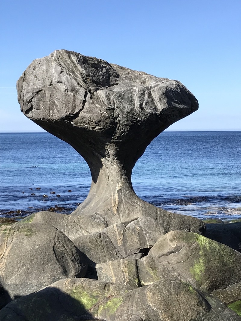
Now back to what has been one of my prime objectives on this trip and this was too get to see the Kannenstein. For anyone that is interested and wish to know where it is located it can be found at 61.96873323N 5.0673580169E an what it looks like this is the first image shown below in this post.
I guess it is about three meters high and just a lump of rock on the shore at, you've guessed it, Kannen. It has all hell beaten out of it over who knows how much time, by stormy seas and fellow rocks blasting away at it. I originally saw an image in a Photographers exhibition, in Black and White. It appealed to me so much I contacted the guy for it’s location and decided “This rock I have to see”.
You folks having seen my iPhone version of it will probably only have your opinion of me as not being all there confirmed, but I can assure you the ride in to see it is worth the effort.
From there started back on a route which will take me back to where I got all gooey about yesterday, (Boss is back home and OK), so having no phone contact not a problem anymore. The little ferry that I need to catch to get across to it doesn't run Sundays so if I don't take the chance tomorrow it'll have to wait until next year. Devious little me has discovered another baby Ferry that I can loop around to and get back to including all the other exciting things I mentioned yesterday. It’s only a detour of 400 kilometres. Hi Ho life just a bundle of fun, I haven't a clue why I spent all those years pretending to be working.
Landed up on a pass crossing from one side of the land mass to the other, about 500 meters up and quite breezy but with views forever.
PPR-42 06.05
Start: 05:30 Finish: 12:00
Total km., for day: 214,8
Camped at: N62°08’34” E6°44’41”.
Bro setting out on his Irish Atlantic Wall ride today. Have fun Squire and stay in the saddle.
Quick breakfast and on the move pronto, wanted to be sure of making the ferry, which worked out just fine. Made it for the 11:10, one after that as 12:45 so had some luck.
So now I’m back on the spot I’ve been all excited about, truly beautiful and serves to remind me just how pitifully tiny we really are. At the same time to have ones nose rub into the fact that to really enjoy it you have to get up into it, which is unfortunately no longer a physical possibility. Observation not self pity, fact of life, imagine whimsical sighs echoing down the valley.
Had a great lunch sitting in the sun enjoying my surroundings. Baby spinach (triple portion) and a 300 gramme chunk of smoked salmon.Main reason for that is to ensure the I don't have the same problems tonight as I did yesterday.
I as so finished after all the driving I couldn't be bothered to organise a decent meal so had a slice of bread with a bit of tinned Mackerel on it, followed by a piece of bread with Reindeer Salami on it and for desert two slices of bread and honey. Seems they didn't seem to get on too well together and wage war al night long.
Will enjoy the rest of the afternoon walking around and watching, quite literally, one big avalanche after the other thundering down on both sides of the valley.Really spectacular if your far enough removed , which needless to say I am, (He hopes).
In between all that hard work have been doing some route planning for the rest of the trip, cant leave it all to poor old Kate, or is it Jane.
PPR-43 07.05
Start: 05:15 Finish: 16:20
Total km., for day: 276,6
Camped at: N61°49’32” E5°25’32”.
Woken at 5 by an avalanche and as I write it’s 8 and they haven't stopped yet. Also heard a couple in the night but didn't disturb much, pretty much like thunder.
On the road at 8:30 and fairly early at screwing things up as well. That’s what you get for getting cocky I guess. I went right instead of left and landed in Volda which is exactly where I didn't want to be sixty kilometres in the wrong direction. No worries, don't have a timetable to keep to. Filled up with fuel, water, check tire pressures and have a sneaky cocoa. Back the way had come and round to the ferry I was aiming for. Only had half am hour to wait and away again.
An interesting drive but a only to done once I think. The whole area consists of an almost sheer sided mountain range and the roads follow around at its base along the sea shore. Well more or less and there are no roads at all into the interior areas. So anything inhabitable, is inhabited, obviously, and by the rules of wild camping cannot camp within 300 meters of any building, even if its a shed on the property perimeter. Thats one rule I always keep or err on the positive side of. Being able to camp where you wish is for me is a privilege and I don't wish to be one of the ones ruining it. Only one camping place in the whole area and it was not open.
Did not really matter as when I arrived where I had thought it would be great to camp, right out on the point at a place called Kalvåg, turned out to be more than breezy, howling would be moral like the correct term. If your interested in where it is put these coordinates into our friend Google thingubmegig, N61°53’23” E5°15’31”, where I ha my lunch, and follow the road west as far as it goes, route 616.
As I’d been counting on camping out there anyway, “cos its a dead end according to the map and I had planned to go back out the way I’d come in tomorrow. Started to do this and coming over a bridge I spotted what I thought might be a possibility to park up for the night, no luck. What was lucky though was as I was coming back off the area I spotted a sign which said 20 Km., to Svelgen my targeted end for the day no matter what. That cannot be right I thought that road leads to a place named Bortnen which is a dead end. For a change I figured they might know better than myself so I took the road. Twenty kilometres instead of over eighty is a good argument in my book, especially if the sixty of them are on a single track road with passing places.
Turns out the were right, in Bortnen the road just kept on. They'd put a hole straight through the mountain and zimzalabim there was a brand new tunnel. Nice surprise. I emerged approximately in the middle of the stretch between the ferry at Isane and Svelgen. I figured the place along that stretch where I might find a spot to camp was a few kilometres back up the road to the ferry and a few more clicks in the wrong direction weren't going to kill me and I took the chance and was right. It turned up 4 kilometres later on the edge of a lake and mister was lord of all he surveyed again. Well that is with the exception of a whacking big truck out of Czechoslovakia , so I let him stay. Great spot and absolutely quiet. Guess the trucker was on his Sunday break and he slept all the time I was there.
PPR-44 08.05
Start: 08:10 Finish: 17:15
Total km., for day: 255,9
Camped at: N61°20’09” E6°24’02”.
Nice slow start, finally crept out of my pit at 8:10, trucker gone, didn't hear him leave so must have slept well.
Started off on an easy run as planned, stopped about 13:00 for lunch and moved on. On the way to the stop checked to some 8,000 year old Stone Age rock carvings, more than 360 of them an a section of smooth rock carved out by a glacier. Fascinating.
I broke off the second leg of the planned route for the day as it was nothing particularly exciting and a dead end too boot.
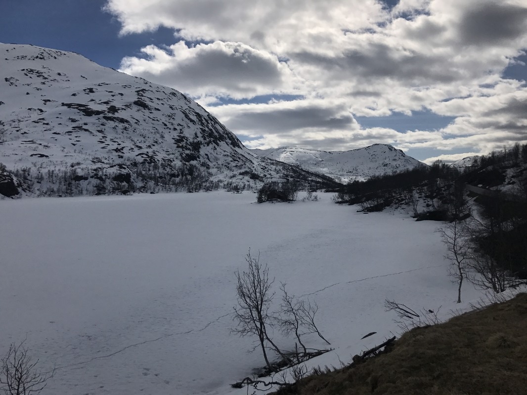
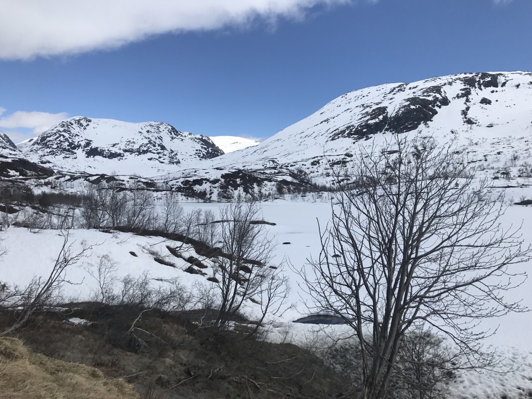
Got back onto the 13 which was also on my planned way out and am camped up with the views left and right as shown, which is at 600 meters above sea level I note on my gizmo.
It’s pretty close to an official campsite we have often used, Saw the guy who owns it yesterday and I can use all his facilities and wifi, which I hope is good enough to allow me to post this. Which is great ‘cos I get to camp further up the pass.
Some interesting old buildings on this stretch and will stay over two nights and try and make something out of them.
The last two images below are left and right of my camping spot.
Start: 06:45 Finish: 17:26
Total km., for day: 207
Camped at: N62°07’47” E6°14’21”.
Woke at 5:00 but crashed out again until 6:45. Moved off at about 9:00 and by the time updated and posted the Blog it was 10:00.
Turned out to be a confused but fantastic day. First off I became really annoyed with the Road Toll System, not because I object to having to paying, although the way it is organised it’s a straight rip off. No simply because the way they do it, and they do it rather effectively, they want to force you into using the main highways.
Stir me being who I am I persevered and found an incredible drive and some great camping spots to boot. The one I wanted to use I left for now as its in a complete mobile signal blackspot which as the Boss is in Hospital back home for an OP I didn't want to risk not being contactable. maybe I will be able to work things so that I can come back through after my Rock image thing and the all clear is sounded from home.
Might be a bit difficult though, I’ve been browsing my map here where I’m camped for the night and have found all sorts of exciting alternatives to my original idea. Sure I ca, we shall see, after all they are only kilometres after all. Hate to think what all the fuel is costing for this traipsing around. Leave that until at home and can't change it then,👹
Camped up out in the boondocks here, looks like the cleared area I’ve chosen is a loggers collection area. Hope I don’t wake up in the morning to find they are early starters and have just taken delivery of a large amount of logs.
PPR-41 05.05
Start: 06:30 Finish: 17:30
Total km., for day: 288
Camped at: N62°06’13” E5°16’07”.
My mate Dieter comes under the knife today. Thinking of you Buddy and you get up and bounce around again ASAP. Please!
Spent quite awhile driving without a clue where the hell I was but finally found out I was on the 651. Nary to worry and my own fault for diving off the road I was on to avoid a long tunnel that suddenly loomed up ahead. Later in the day on a break and a lot of rooting around on my raging maps found the road and how I managed to get on it. Either way no harm done, rather the opposite, another one for the list. Tremendously interesting and scenic as hell.
Now back to what has been one of my prime objectives on this trip and this was too get to see the Kannenstein. For anyone that is interested and wish to know where it is located it can be found at 61.96873323N 5.0673580169E an what it looks like this is the first image shown below in this post.
I guess it is about three meters high and just a lump of rock on the shore at, you've guessed it, Kannen. It has all hell beaten out of it over who knows how much time, by stormy seas and fellow rocks blasting away at it. I originally saw an image in a Photographers exhibition, in Black and White. It appealed to me so much I contacted the guy for it’s location and decided “This rock I have to see”.
You folks having seen my iPhone version of it will probably only have your opinion of me as not being all there confirmed, but I can assure you the ride in to see it is worth the effort.
From there started back on a route which will take me back to where I got all gooey about yesterday, (Boss is back home and OK), so having no phone contact not a problem anymore. The little ferry that I need to catch to get across to it doesn't run Sundays so if I don't take the chance tomorrow it'll have to wait until next year. Devious little me has discovered another baby Ferry that I can loop around to and get back to including all the other exciting things I mentioned yesterday. It’s only a detour of 400 kilometres. Hi Ho life just a bundle of fun, I haven't a clue why I spent all those years pretending to be working.
Landed up on a pass crossing from one side of the land mass to the other, about 500 meters up and quite breezy but with views forever.
PPR-42 06.05
Start: 05:30 Finish: 12:00
Total km., for day: 214,8
Camped at: N62°08’34” E6°44’41”.
Bro setting out on his Irish Atlantic Wall ride today. Have fun Squire and stay in the saddle.
Quick breakfast and on the move pronto, wanted to be sure of making the ferry, which worked out just fine. Made it for the 11:10, one after that as 12:45 so had some luck.
So now I’m back on the spot I’ve been all excited about, truly beautiful and serves to remind me just how pitifully tiny we really are. At the same time to have ones nose rub into the fact that to really enjoy it you have to get up into it, which is unfortunately no longer a physical possibility. Observation not self pity, fact of life, imagine whimsical sighs echoing down the valley.
Had a great lunch sitting in the sun enjoying my surroundings. Baby spinach (triple portion) and a 300 gramme chunk of smoked salmon.Main reason for that is to ensure the I don't have the same problems tonight as I did yesterday.
I as so finished after all the driving I couldn't be bothered to organise a decent meal so had a slice of bread with a bit of tinned Mackerel on it, followed by a piece of bread with Reindeer Salami on it and for desert two slices of bread and honey. Seems they didn't seem to get on too well together and wage war al night long.
Will enjoy the rest of the afternoon walking around and watching, quite literally, one big avalanche after the other thundering down on both sides of the valley.Really spectacular if your far enough removed , which needless to say I am, (He hopes).
In between all that hard work have been doing some route planning for the rest of the trip, cant leave it all to poor old Kate, or is it Jane.
PPR-43 07.05
Start: 05:15 Finish: 16:20
Total km., for day: 276,6
Camped at: N61°49’32” E5°25’32”.
Woken at 5 by an avalanche and as I write it’s 8 and they haven't stopped yet. Also heard a couple in the night but didn't disturb much, pretty much like thunder.
On the road at 8:30 and fairly early at screwing things up as well. That’s what you get for getting cocky I guess. I went right instead of left and landed in Volda which is exactly where I didn't want to be sixty kilometres in the wrong direction. No worries, don't have a timetable to keep to. Filled up with fuel, water, check tire pressures and have a sneaky cocoa. Back the way had come and round to the ferry I was aiming for. Only had half am hour to wait and away again.
An interesting drive but a only to done once I think. The whole area consists of an almost sheer sided mountain range and the roads follow around at its base along the sea shore. Well more or less and there are no roads at all into the interior areas. So anything inhabitable, is inhabited, obviously, and by the rules of wild camping cannot camp within 300 meters of any building, even if its a shed on the property perimeter. Thats one rule I always keep or err on the positive side of. Being able to camp where you wish is for me is a privilege and I don't wish to be one of the ones ruining it. Only one camping place in the whole area and it was not open.
Did not really matter as when I arrived where I had thought it would be great to camp, right out on the point at a place called Kalvåg, turned out to be more than breezy, howling would be moral like the correct term. If your interested in where it is put these coordinates into our friend Google thingubmegig, N61°53’23” E5°15’31”, where I ha my lunch, and follow the road west as far as it goes, route 616.
As I’d been counting on camping out there anyway, “cos its a dead end according to the map and I had planned to go back out the way I’d come in tomorrow. Started to do this and coming over a bridge I spotted what I thought might be a possibility to park up for the night, no luck. What was lucky though was as I was coming back off the area I spotted a sign which said 20 Km., to Svelgen my targeted end for the day no matter what. That cannot be right I thought that road leads to a place named Bortnen which is a dead end. For a change I figured they might know better than myself so I took the road. Twenty kilometres instead of over eighty is a good argument in my book, especially if the sixty of them are on a single track road with passing places.
Turns out the were right, in Bortnen the road just kept on. They'd put a hole straight through the mountain and zimzalabim there was a brand new tunnel. Nice surprise. I emerged approximately in the middle of the stretch between the ferry at Isane and Svelgen. I figured the place along that stretch where I might find a spot to camp was a few kilometres back up the road to the ferry and a few more clicks in the wrong direction weren't going to kill me and I took the chance and was right. It turned up 4 kilometres later on the edge of a lake and mister was lord of all he surveyed again. Well that is with the exception of a whacking big truck out of Czechoslovakia , so I let him stay. Great spot and absolutely quiet. Guess the trucker was on his Sunday break and he slept all the time I was there.
PPR-44 08.05
Start: 08:10 Finish: 17:15
Total km., for day: 255,9
Camped at: N61°20’09” E6°24’02”.
Nice slow start, finally crept out of my pit at 8:10, trucker gone, didn't hear him leave so must have slept well.
Started off on an easy run as planned, stopped about 13:00 for lunch and moved on. On the way to the stop checked to some 8,000 year old Stone Age rock carvings, more than 360 of them an a section of smooth rock carved out by a glacier. Fascinating.
I broke off the second leg of the planned route for the day as it was nothing particularly exciting and a dead end too boot.
Got back onto the 13 which was also on my planned way out and am camped up with the views left and right as shown, which is at 600 meters above sea level I note on my gizmo.
It’s pretty close to an official campsite we have often used, Saw the guy who owns it yesterday and I can use all his facilities and wifi, which I hope is good enough to allow me to post this. Which is great ‘cos I get to camp further up the pass.
Some interesting old buildings on this stretch and will stay over two nights and try and make something out of them.
The last two images below are left and right of my camping spot.