PPR-45 09.05
Start: 06:15 Finish: 18:30
Total km., for day: 219,4
Camped at: N60°55’32” E7°04’45”.
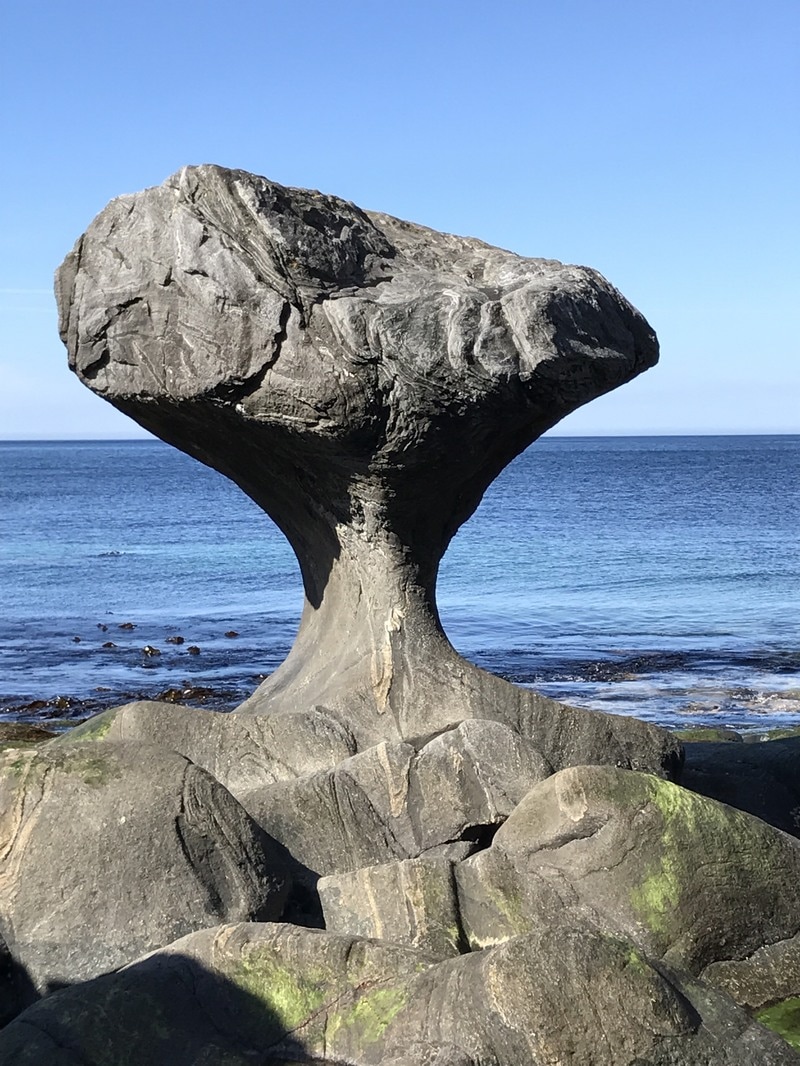
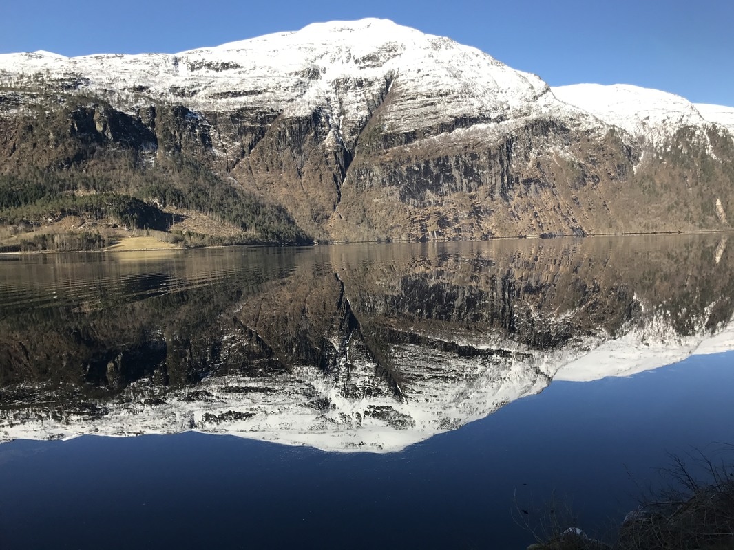
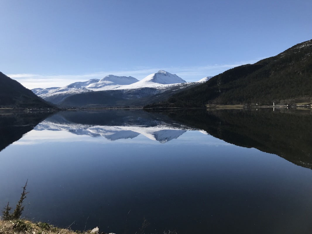
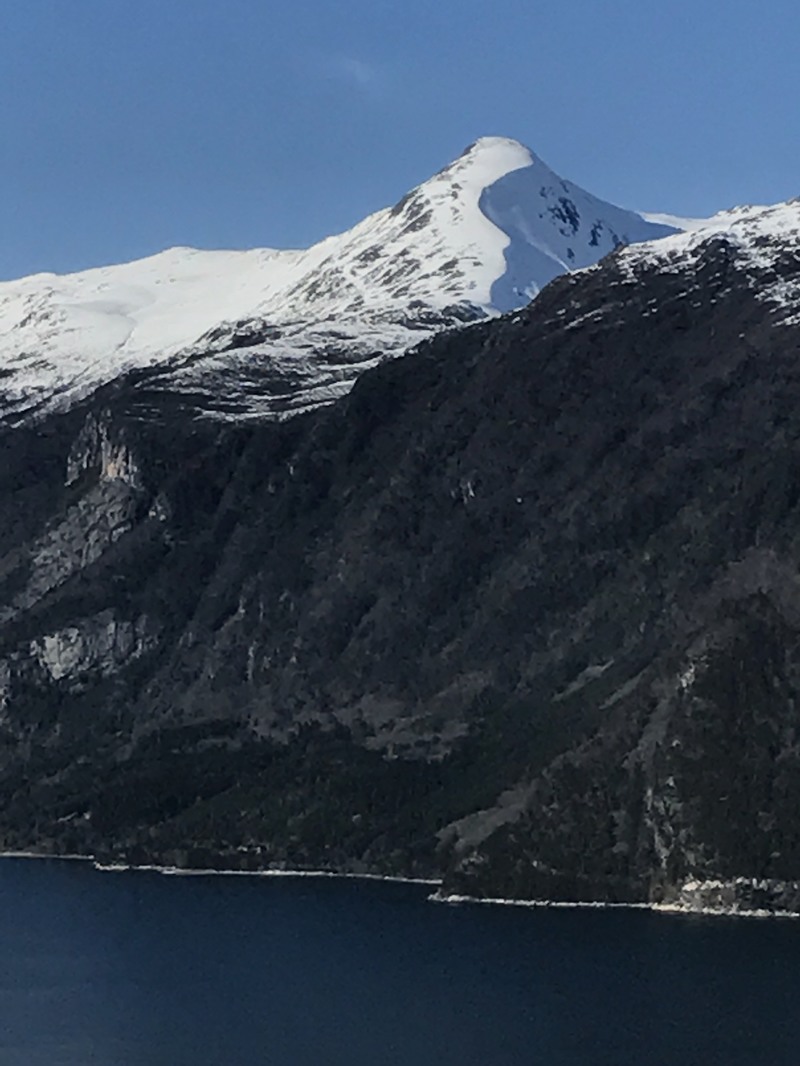
Great nights sleep again, something I seem good at. Quite a surprise to peek out and find myself in the clouds which is hardly surprising I suppose at 600 meters, snowing as well. I took it slowly as it looked as though it might clear up for me to try for my images.
Drove down to the camp site, updated the Blog and stuff and drove down into the village in the valley back the way I’d come in yesterday to the only shop for literally miles around. Could have saved my self the trouble, I almost had more in the van as leftovers than they did. Nary mind, means I can try for my images back in as they are all on the way. Started raining during this, of course.
Going past the camp site again I dived in to take advantage of the good wifi connection to check the weather. This changed my timing drastically but not my route.
Heavy snow storms moving in over the whole area that I had planned to be whiling in for the next couple of days so I decided to scarper rather than risk getting stuck up high.
From here I have to negotiate a quite steep pass, which reminds me of the Ouzzlem Bird as the Pass is so well blessed in hairpin bends I might just finish up like him, to arrive at the Ferry across the fjord. This gives me the run into the pass up over the Fjell and back down again into Voss. Only 200 kilometres but more than interesting ones. They shut the passes down as soon as real bad weather comes in and then its wait and convoy time. Don't really need all that.
Turns out to have been a good decision as I learnt waiting at a tunnel to be driven through in convoy due to roadworks in it. Seems the area I was “fleeing” from was more or less shutting down behind me as I drove out due to the storm up above the snow line.
This stretch is a continuous tunnel, or at least that’s the feeling one gets. I’m on the E16 as there is no other possibility through these high mountains. This evening I took a sharp left coming out of an eleven kilometre long one. Where you exit it you literally just have time to grab a breath before disappearing into the next one which is only five kilometres long.
The E16 is like this for kilometres. In the morning I have to go through the five kilometre one and then a series of baby ones until you have the choice of going North. This takes you through what I believe is currently the longest one in the world. Twenty five kilometres of it. Alternatively you can go Southeast down the 50 through a series of shorter ones.
Me I’m going Southeast, we went through the long one in 2008, great piece of engineering, wide, well light etc., but as boring as hell. Apart from which if you go that way its hard to play “Who can hold their breath going through?”
Anyway after my sharp left I drove down to the bottom of the road to a small village, Undredal, on a very large Fjord. Where much to my surprise I realised I had been before on our 2008 trip, never been able to remember where it was.
Went halfway back up the road to a spot ID’d as my overnight home, probably go into the village again before leaving for a couple of buildings.
Great camp nice and quiet.
PPR-46 10.05
Start: 06:30 Finish: 17:15
Total km., for day: 309,7
Camped at: N61°02’36” E7°47’45”.
Once on the move back for the images then out onto the E16 and dived off down the 50. It wasn't really surprising that it started to snow and didn't stop until about 16:00.
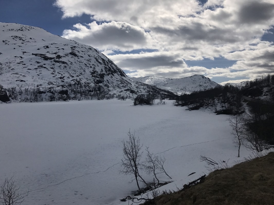
The climb up the mountain through the pass to get up on the Fjell was truly amazing with some equally amazing tunnels. Once up on top the snow was really getting into its act and the temperature dropped down to -3,5°C, really wild up there. Hats off to the road and tunnel builders, power line folks as well.
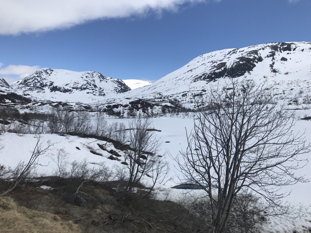
Came down off the 50 onto the 7 and along to Gol, and from there up and over again, not as high and wild but still windy and snow. This brings you down into a small village called Borgund, just off the E16 where there is a Stavkirke, look it up if your interested, there are only twenty-eight of them left in Norway. They are really old wooden churches, quite amazing old things.
Start heading North again tomorrow I’ve decided to go via Dombås and over the Dovrefjell. There are Musk Ox up there, not that I’m likely to catch a glimpse.
PPR-47 11.05
Start: 06:00 Finish: 15:26
Total km., for day: 271,8
Camped at: N61°52’27” E9°05’56”.
Up early and moved a little closer to the church for breakfast as I was camped somewhere I shouldn't have been.
From there about eight kilometres down the road to a truckers stop to use the WC facilities the local authorities provide. Get to wash and brush up with hot water and in conditions slightly less cramped than in the van.
After that off on the route the SatNav had planned, and I’d approved, until she started to take me up a mountain on uncleared gravel roads. Gave her the rest of the day off, switched her off for a rest. Bit too hairy what she was asking of man and material and I chose my own way.
At Fagernes topped up on all the necessary fuels, diesel, water and a cuppa cocoa and good to go for fair while again. Picked up the 51 which up and over the pass onto the Fjell. Incredible amount of snow up there but the road completely cleared. Most of the peaks are over 1,500 meters plus so hardly a surprise. That drops down into Vågåmo, an interesting little town, boast its own Stavkirke from 1,100, and was a favourite place of Edvard Munch for the artists amongst you. The Scream?
Spent sometime walking about, back starting to give a bit of gyp. Camped on the large Parking area at the entrance into town. Lots of wonderful opportunities up on the Fjell, but everywhere it was possible they had put up big unmissable NO CAMPING signs the buggers, so didn't have much choice.
Got quite an interesting route for my drive out of this great country, just have to see how it pans out.
At least this spot is quiet, maybe because it backs onto the Kirke Graveyard.👻
PPR-48 12.05
Start: 06:15 Finish: 14:15
Total km., for day: 171,9
Camped at: N61°58’45” E10°01’32”.
Milk off, no breakfast, what a bummer.
Unbelievable camping spot off the 27 near Folldal, its right off the road in the trees and bush in an area with quite a few clearings with campfire sites right on the river. Guess its popular with the Angler folks in season.
When I arrived sun was shining temperature about 8°C so I grab the chance and threw open every door, cupboard and any storage areas and took out all bedding, fleece jackets etc., and gave everything a good long deserved airing. I have a vague suspicion that the interior smelt a wee bit like and animal transporter. Really hasn't been a chance before to do so.
If the weather is like this in the morning might risk a quick skinny dip in the river and wash properly.
Van all packed and closed up by 18:00, sun disappeared behind the mountain and it cooled off pretty quick then.
The normal route out of Vågåmo takes you down the E6 which is the worst Euroroute of all, it serves as the main arterial road straight through Norway, South to North and every Tom, Dick, Harry and all their relations use it. So I just told Kate take me here but DO NOT USE the E6 to do it. Great move, didn't touch it once, she took me mostly up on the hillside high over the E6 on the other side of the river and all the way down to the 27, which is where I wanted to be.
The 27 took me where else than up and over another Fjell. Plenty snow again, too much to get off the beaten track but found a grand spot for a good old Omani style Mountain and Desert trip lunch. Sardines in oil and dry bread. Unfortunately not the Omani bread.
PPR-49 13.05
Start: 06:45 Finish: 17:20
Total km., for day: 197,5
Camped at: N63°04’12” E9°53’18”.
WOW, it was cold in the night, ice on the inside of the van windows when I woke and the ground temperature was -4°C. I am more than snug in my sleeping arrangement so didn't notice. Did make me change my mind about a quick wash in thriver though.
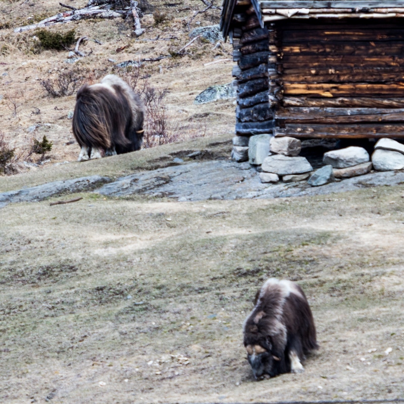
It soon warmed up as the sun came up and a wonderful run up to the E6, which unfortunately is the only road over the Dovrefjell. Where the road starts to go down towards Oppdal there is an old way station on the right and a bit further on the left an old, but in service, Railway Station. About 100 meters before the way station I nearly fell off my perch, I had difficulty in realising my amazing luck. Two Musk Ox grazing away. There are about 200 hundred in Norway and they all roam about up here on the Fjell and are rarely seen and very shy. Outside of seeing them in animal documentaries I never thought I’d get to see one in the wild. Grabbed camera, 200mm lens and a 2x converter. Lets hope!
After that into Oppdal tanked up again and left down the 70 until I could hang a right. This I did and the whole way until this stop, which I cannot exactly locate on the map, but have the coordinates, I was in my own little heaven, dirt roads all the way, camped off it as well.
Just off a bridge with a rapids hurtling through under it.
PPR-50 14.05
Start: 07:00 Finish: 18:25
Total km., for day: 301,6
Camped at: N63°11’18” E11°09’18”.
Not a bad night considering the noise the rapids made. Loafed around a bit just enjoying some sunshine and the location before heading off and down to where I connected with the 705, dirt all the way but good eighty kilometres in all. Changed my route on a whim and decided to shoot up to the Swedish boarder. Mistake was a lousy run, E14, all the way up to the boarder I kept feeling some things were vaguely familiar until just before the boarder two signs, fairly close to each other gave my memory a wee bit of a nudge and I decided to investigate on the way back down from the boarder.
On the way back I checked out the signs and sure enough I had been through this way before with Brigitte on our last trip up here. Only we had come down from up North, Narvik I think, via Sweden and had been going in the opposite direction back into Norway.
The second sign I followed took me into the location of an interesting “Wooden” Dam, and Lake. It was where we had camped last time. So I had my lunch there for old times sake.
On the way back down to where I could exit the E14 all sorts of things suddenly slotted into place. Amazing how the direction of travel makes such a difference.
Where I have landed for the day is about where I had planned for my jumping off point on the drive down south and home. Kate was making a real dogs breakfast of finding exactly where I wanted to be so I fired her and headed up into the hills and found a suitable abode.
PPR-51 15.05
Start: 07:00 Finish: 17:50
Total km., for day: 279,4
Camped at: N62°16’24” E10°46’25”.
The day was everything other than planned. This was to explore the very interesting looking small roads between the 30 and the Swedish boarder. It turned out to be an absolute no go for two reasons:
These images will help to support the facts, at least to point 2 anyway. The first image is the view on the righthand side of the van and the second the lefthand side. I was on the only open road through the area.
Start: 06:15 Finish: 18:30
Total km., for day: 219,4
Camped at: N60°55’32” E7°04’45”.
Great nights sleep again, something I seem good at. Quite a surprise to peek out and find myself in the clouds which is hardly surprising I suppose at 600 meters, snowing as well. I took it slowly as it looked as though it might clear up for me to try for my images.
Drove down to the camp site, updated the Blog and stuff and drove down into the village in the valley back the way I’d come in yesterday to the only shop for literally miles around. Could have saved my self the trouble, I almost had more in the van as leftovers than they did. Nary mind, means I can try for my images back in as they are all on the way. Started raining during this, of course.
Going past the camp site again I dived in to take advantage of the good wifi connection to check the weather. This changed my timing drastically but not my route.
Heavy snow storms moving in over the whole area that I had planned to be whiling in for the next couple of days so I decided to scarper rather than risk getting stuck up high.
From here I have to negotiate a quite steep pass, which reminds me of the Ouzzlem Bird as the Pass is so well blessed in hairpin bends I might just finish up like him, to arrive at the Ferry across the fjord. This gives me the run into the pass up over the Fjell and back down again into Voss. Only 200 kilometres but more than interesting ones. They shut the passes down as soon as real bad weather comes in and then its wait and convoy time. Don't really need all that.
Turns out to have been a good decision as I learnt waiting at a tunnel to be driven through in convoy due to roadworks in it. Seems the area I was “fleeing” from was more or less shutting down behind me as I drove out due to the storm up above the snow line.
This stretch is a continuous tunnel, or at least that’s the feeling one gets. I’m on the E16 as there is no other possibility through these high mountains. This evening I took a sharp left coming out of an eleven kilometre long one. Where you exit it you literally just have time to grab a breath before disappearing into the next one which is only five kilometres long.
The E16 is like this for kilometres. In the morning I have to go through the five kilometre one and then a series of baby ones until you have the choice of going North. This takes you through what I believe is currently the longest one in the world. Twenty five kilometres of it. Alternatively you can go Southeast down the 50 through a series of shorter ones.
Me I’m going Southeast, we went through the long one in 2008, great piece of engineering, wide, well light etc., but as boring as hell. Apart from which if you go that way its hard to play “Who can hold their breath going through?”
Anyway after my sharp left I drove down to the bottom of the road to a small village, Undredal, on a very large Fjord. Where much to my surprise I realised I had been before on our 2008 trip, never been able to remember where it was.
Went halfway back up the road to a spot ID’d as my overnight home, probably go into the village again before leaving for a couple of buildings.
Great camp nice and quiet.
PPR-46 10.05
Start: 06:30 Finish: 17:15
Total km., for day: 309,7
Camped at: N61°02’36” E7°47’45”.
Once on the move back for the images then out onto the E16 and dived off down the 50. It wasn't really surprising that it started to snow and didn't stop until about 16:00.
The climb up the mountain through the pass to get up on the Fjell was truly amazing with some equally amazing tunnels. Once up on top the snow was really getting into its act and the temperature dropped down to -3,5°C, really wild up there. Hats off to the road and tunnel builders, power line folks as well.
Came down off the 50 onto the 7 and along to Gol, and from there up and over again, not as high and wild but still windy and snow. This brings you down into a small village called Borgund, just off the E16 where there is a Stavkirke, look it up if your interested, there are only twenty-eight of them left in Norway. They are really old wooden churches, quite amazing old things.
Start heading North again tomorrow I’ve decided to go via Dombås and over the Dovrefjell. There are Musk Ox up there, not that I’m likely to catch a glimpse.
PPR-47 11.05
Start: 06:00 Finish: 15:26
Total km., for day: 271,8
Camped at: N61°52’27” E9°05’56”.
Up early and moved a little closer to the church for breakfast as I was camped somewhere I shouldn't have been.
From there about eight kilometres down the road to a truckers stop to use the WC facilities the local authorities provide. Get to wash and brush up with hot water and in conditions slightly less cramped than in the van.
After that off on the route the SatNav had planned, and I’d approved, until she started to take me up a mountain on uncleared gravel roads. Gave her the rest of the day off, switched her off for a rest. Bit too hairy what she was asking of man and material and I chose my own way.
At Fagernes topped up on all the necessary fuels, diesel, water and a cuppa cocoa and good to go for fair while again. Picked up the 51 which up and over the pass onto the Fjell. Incredible amount of snow up there but the road completely cleared. Most of the peaks are over 1,500 meters plus so hardly a surprise. That drops down into Vågåmo, an interesting little town, boast its own Stavkirke from 1,100, and was a favourite place of Edvard Munch for the artists amongst you. The Scream?
Spent sometime walking about, back starting to give a bit of gyp. Camped on the large Parking area at the entrance into town. Lots of wonderful opportunities up on the Fjell, but everywhere it was possible they had put up big unmissable NO CAMPING signs the buggers, so didn't have much choice.
Got quite an interesting route for my drive out of this great country, just have to see how it pans out.
At least this spot is quiet, maybe because it backs onto the Kirke Graveyard.👻
PPR-48 12.05
Start: 06:15 Finish: 14:15
Total km., for day: 171,9
Camped at: N61°58’45” E10°01’32”.
Milk off, no breakfast, what a bummer.
Unbelievable camping spot off the 27 near Folldal, its right off the road in the trees and bush in an area with quite a few clearings with campfire sites right on the river. Guess its popular with the Angler folks in season.
When I arrived sun was shining temperature about 8°C so I grab the chance and threw open every door, cupboard and any storage areas and took out all bedding, fleece jackets etc., and gave everything a good long deserved airing. I have a vague suspicion that the interior smelt a wee bit like and animal transporter. Really hasn't been a chance before to do so.
If the weather is like this in the morning might risk a quick skinny dip in the river and wash properly.
Van all packed and closed up by 18:00, sun disappeared behind the mountain and it cooled off pretty quick then.
The normal route out of Vågåmo takes you down the E6 which is the worst Euroroute of all, it serves as the main arterial road straight through Norway, South to North and every Tom, Dick, Harry and all their relations use it. So I just told Kate take me here but DO NOT USE the E6 to do it. Great move, didn't touch it once, she took me mostly up on the hillside high over the E6 on the other side of the river and all the way down to the 27, which is where I wanted to be.
The 27 took me where else than up and over another Fjell. Plenty snow again, too much to get off the beaten track but found a grand spot for a good old Omani style Mountain and Desert trip lunch. Sardines in oil and dry bread. Unfortunately not the Omani bread.
PPR-49 13.05
Start: 06:45 Finish: 17:20
Total km., for day: 197,5
Camped at: N63°04’12” E9°53’18”.
WOW, it was cold in the night, ice on the inside of the van windows when I woke and the ground temperature was -4°C. I am more than snug in my sleeping arrangement so didn't notice. Did make me change my mind about a quick wash in thriver though.
It soon warmed up as the sun came up and a wonderful run up to the E6, which unfortunately is the only road over the Dovrefjell. Where the road starts to go down towards Oppdal there is an old way station on the right and a bit further on the left an old, but in service, Railway Station. About 100 meters before the way station I nearly fell off my perch, I had difficulty in realising my amazing luck. Two Musk Ox grazing away. There are about 200 hundred in Norway and they all roam about up here on the Fjell and are rarely seen and very shy. Outside of seeing them in animal documentaries I never thought I’d get to see one in the wild. Grabbed camera, 200mm lens and a 2x converter. Lets hope!
After that into Oppdal tanked up again and left down the 70 until I could hang a right. This I did and the whole way until this stop, which I cannot exactly locate on the map, but have the coordinates, I was in my own little heaven, dirt roads all the way, camped off it as well.
Just off a bridge with a rapids hurtling through under it.
PPR-50 14.05
Start: 07:00 Finish: 18:25
Total km., for day: 301,6
Camped at: N63°11’18” E11°09’18”.
Not a bad night considering the noise the rapids made. Loafed around a bit just enjoying some sunshine and the location before heading off and down to where I connected with the 705, dirt all the way but good eighty kilometres in all. Changed my route on a whim and decided to shoot up to the Swedish boarder. Mistake was a lousy run, E14, all the way up to the boarder I kept feeling some things were vaguely familiar until just before the boarder two signs, fairly close to each other gave my memory a wee bit of a nudge and I decided to investigate on the way back down from the boarder.
On the way back I checked out the signs and sure enough I had been through this way before with Brigitte on our last trip up here. Only we had come down from up North, Narvik I think, via Sweden and had been going in the opposite direction back into Norway.
The second sign I followed took me into the location of an interesting “Wooden” Dam, and Lake. It was where we had camped last time. So I had my lunch there for old times sake.
On the way back down to where I could exit the E14 all sorts of things suddenly slotted into place. Amazing how the direction of travel makes such a difference.
Where I have landed for the day is about where I had planned for my jumping off point on the drive down south and home. Kate was making a real dogs breakfast of finding exactly where I wanted to be so I fired her and headed up into the hills and found a suitable abode.
PPR-51 15.05
Start: 07:00 Finish: 17:50
Total km., for day: 279,4
Camped at: N62°16’24” E10°46’25”.
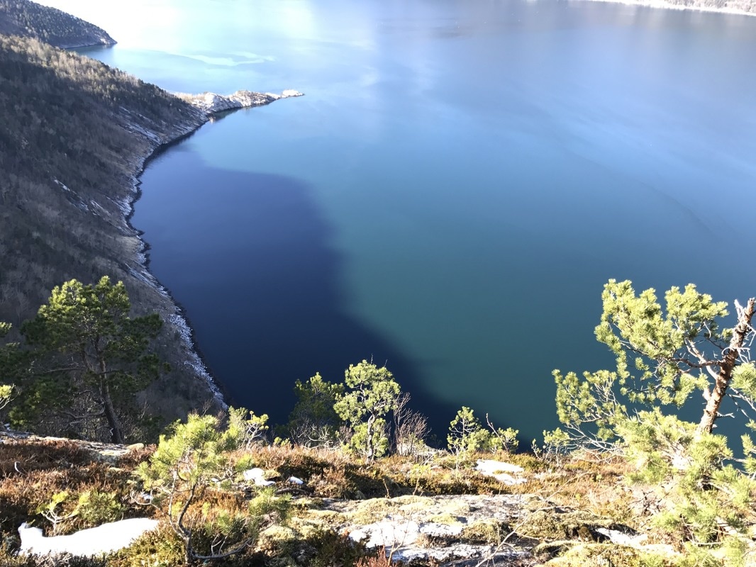
The day was everything other than planned. This was to explore the very interesting looking small roads between the 30 and the Swedish boarder. It turned out to be an absolute no go for two reasons:
- They are either private roads, toll roads or both.
- More importantly they do not open until the beginning of June, earliest.
These images will help to support the facts, at least to point 2 anyway. The first image is the view on the righthand side of the van and the second the lefthand side. I was on the only open road through the area.


Instant switch to plan B and off down the 30. Saw plenty of interesting stuff, one was a very large and handsome looking Elk who was taking a break in a lay by, until I showed up, and one very startled and frightened deer, with antlers I might add. He was stood in the middle of the road in a curve and if I hadn't hit the brakes full on both he and the front of the van would have looked quite sorry for themselves. He took off with rather relaxed set of bowels into the trees, thank goodness. Also spotted a lot of Goosander on a lake and a Grey Plover, yes I am sure, and he was a long way inland from where he was supposed to be.
I finally landed up in Tynset again on this trip as fool that I am I couldn't find an excellent and remote camping place that we have used before.
Camped on the parking lot close to the railway station which turned out to be pretty noisy up until about 2 am., due to all the boy racers giving it stick all over with Harvey Wallbanger style music blaring out at Trini Maxi Taxi volume. Even my van metalwork was vibrating with it. I just hope the were Daddies vehicles and that they bent them before they got home.
All in all I had a good day but one that can be categorised as an “Oh, I think I’d better think it out again,” day. I enjoyed it all the same.
PPR-52 16.05
Start: 06:00 Finish: 09:20
Total km., for day: 28
Camped at: N62°25’36” E11°05’27”.
Very short day and one that reinforces the fact that I’m and idiot. I could get no peace over not having found the camp site I had wanted so decided I would locate it before moving on.
Easy explanation I had it in my head that it was off the E3 just outside of Tynset going north to Trondheim,. It’s off the 30 just twenty eight kilometres, as you can see from todays kilometre tally, just before coming into Tynset from Røros, passed in on the way in last night. Oaf!!!
So here I is, and here I stays, it really is a lovely spot so no more driving for the day. Chance to catch up on the blog and do some walking for the back, it really does need it.
There were plenty of places with wifi connections in Tynset, which I have to drive through tomorrow, that should be good enough for me to make another post.
Most important part of todays post, wildlife seen, Mouse out on a bridge pontoon in the middle of this rather large river?
Bugger, sitting outside of a large Supermarket doing this 17.05 at 09:00 and wondering why they are still closed. Opening time is 08:00. Jest checked on the web, todays a public holiday. Someone is going to be bit peckish by the end of the day.😕
NOTE TO BLOG POSTS:
This will be the last one before I’m back home I think, the last two weeks I shall be flitting about all overrun my way going down south trying to find places I’ve never been to before, need some Brownie points with the Boss who wants to come up again next year for a bye-bye visit. I think Norway has been pretty well covered by us, both together and alone, over the years, and they are telling a bit on the driver as well.
I shall be doing what I have done all of the trip and keeping notes for the sake of completion and my own personal record of what, when, where and I shall post them for those that are interested on how I found my way home.
Stop before last will be the first stop as on the way up. With the guys that put the van together for me to get the electrical trip switch replaced and that is bridged out at the moment.
I’m with them on the morning of the 31.05 so don't be expecting anything much before end of first week in June.